Engineering Surveying (Theory Portion Only)
| Site: | Prabidhik Notes |
| Course: | Engineering Surveying I |
| Book: | Engineering Surveying (Theory Portion Only) |
| Printed by: | Guest user |
| Date: | Thursday, 25 June 2026, 11:40 AM |
Table of contents
- 1. Introduction to Surveying
- 1.1. Definition of Surveying
- 1.2. Objectives of Surveying
- 1.3. Uses of Surveying
- 1.4. Classification of Surveying
- 1.5. Basic Principles of Surveying
- 1.6. Definition of scale- Full Size Scale, Reducing Scale, and Enlarging Scale
- 1.7. Representative Fraction
- 1.8. Types of Scale – Plain Scale, Diagonal Scale, Scale of Chord and Vernier Scale
- 2. Measurement of Distance
- 3. Reliability of Survey
- 4. Chain Survey
- 5. Compass Survey
- 6. Leveling
1. Introduction to Surveying
1.1. Definition of Surveying
Surveying is an art of determining relative position of the distinctive features on the surface of the earth or beneath the surface of the earth with the help of the angular and linear measurement.
1.2. Objectives of Surveying
The main objective of surveying is the preparation of maps and plans showing the relative position of the existing features by which areas volumes and other related quantities are determined.
The objective of surveying is to :
- Prepare the plans and maps of an area.
- Collect field data.
- Analyze and calculate field parameters for setting out operation of actual engineering works.
- Set out field parameters at the site for further engineering works.
1.3. Uses of Surveying
The uses of surveying are as follows:
- to prepare topographical maps showing hill, river, valley, etc.
- to prepare cadastral map.
- to prepare contour map.
- to prepare military map.
- to determine the best possible route for roads, railways, canals, etc.
- to determine capacity of reservoir.
- to prepare plans and location map.
- to prepare archeological map.
- to prepare geological map.
1.4. Classification of Surveying
We can classify survey on the basis of curvature of earth, nature of field, purpose of survey and instrument used.
The various classification of survey are as follows:
I. On the basis of curvature of earth
a. Plane Survey
- Curvature of earth is ignored.
- If survey area is less than 260 km2.
b. Geodetic survey
- Curvature of earth is considered.
- If survey area is greater than 260 km2.
II. On the basis of nature of field
a. Land survey
- Survey carried on the land surface
- Further classified into topographical survey, cadastral survey and city survey
b. Hydrographic survey
- Survey carried out for study of large water bodies
c. Astronomical survey
- Survey carried out for study of bodies to determine location and direction of any line on the earth surface
III. On the basis of purpose of survey
- Engineering survey
- Reconnaissance survey
- Preliminary survey
- Location survey
- Military survey
- Mine survey
- Geological survey
- Archeological survey
IV. On the basis of instrument used
- Chain survey
- Compass survey
- Plain table survey
- Levelling
- Theodolite survey
- Tacheometric survey
- Triangulation survey
- Aerial survey
- Photogrammetric survey
1.5. Basic Principles of Surveying
The basic principle of surveying are
i. Working from whole to part
ii. Location of a point by measurement from two control points
The principles of surveying are explained below:
I. Working from whole to part:
According to this principle when area is to be surveyed first a system of control points is to be established covering the whole area with high precision then minor details are located by less precise method.
Picture
II. Location of a point by measurement from two control points
According to this principle the relative position of a point to be surveyed should be located by measurement from at least two points of reference the position of which have already been fixed.
Picture
Here, P and Q are control points and R is to be surveyed.
1.6. Definition of scale- Full Size Scale, Reducing Scale, and Enlarging Scale
Scale is defined as the fixed proportion at which every distance between locations of the point on the map is equal to their corresponding distances between their positions on the ground.
The scale can be represented by two ways. They are:
Scale: 1cm=1m or 1cm=100cm or 1:100
Representative fraction: RF = \( \frac{1}{100} \)
The various types of scales on the basis of proportion are as follows:
a. Reducing scale
If the dimensions on the drawing is smaller than the actual dimensions of object, the scale adopted is called reducing scale. It is represented by 1cm=100cm or 1:100 or RF = \( \frac{1}{100} \)
b. Full size scale
If the dimension on the drawing is equal to the actual dimension of the object, the scale adopted is called full size scale. It is represented by 1cm=1cm or 1:1 or RF = \( \frac{1}{1} \)
c. Enlarging scale
If the dimension on the drawing is larger than the actual dimension of the object, the scale adopted is called enlarging scale. It is represented by 10cm=1cm or 10:1 or RF = \( \frac{1}{0.1} \)
1.7. Representative Fraction
When a scale is expressed as a fraction having numerator and denominator in same unit and keeping numerator as unity (i.e. 1) is called representative fraction. For eg: RF = \( \frac{1}{100} \)
1.8. Types of Scale – Plain Scale, Diagonal Scale, Scale of Chord and Vernier Scale
a. Plane scale
Plain scale are used to read our measure length up to two units or unit and its one sub division such as centimeter(cm) and millimeter(mm). It can measure length upto first decimal (eg. 2.5cm). It consists of a line divided into number of equal main part and the first main part is subdivided into smaller parts.
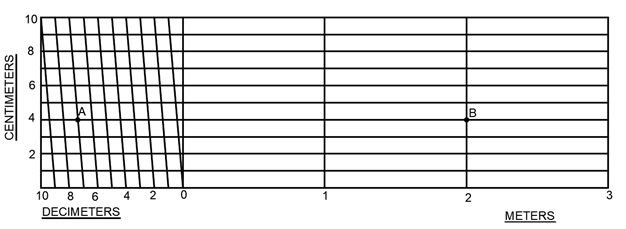
b. Diagonal scale
Diagonal scales are used to read or measure length up to three units (for example, decimeter(dm) centimeter(cm) and millimeters(mm)). It can measure length upto second decimal (eg. 2.54dm).
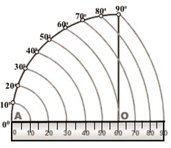
c. Scale of chord
A scale of chord may be used to set or read an angle in the absence of a protractor. The constructions are based on the length of chord of angle measured on the same arc.
d.Vernier scale
A vernier scale is used to measure three consecutive units of a metric scale. It can measure length up to second decimal (eg. 3.45 dm). Its accuracy in measurement is equivalent to that of diagonal scale. It consists of two parts: a. Main scale and b. Vernier scale
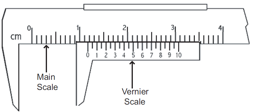
Vernier scale are of two types
i. Direct vernier scale (Forward vernier scale)
- Smallest division of main scale > Smallest division of vernier scale
- Least count = smallest division of main scale – smallest division of vernier scale
ii. Retrograde vernier scale (Backward vernier scale)
- Smallest division of main scale < Smallest division of vernier scale
- Least count = smallest division on vernier scale – smallest division on main scale
2. Measurement of Distance
asap
3. Reliability of Survey
asap
4. Chain Survey
asap
5. Compass Survey
asap
6. Leveling
asap